Statistics Mauritius 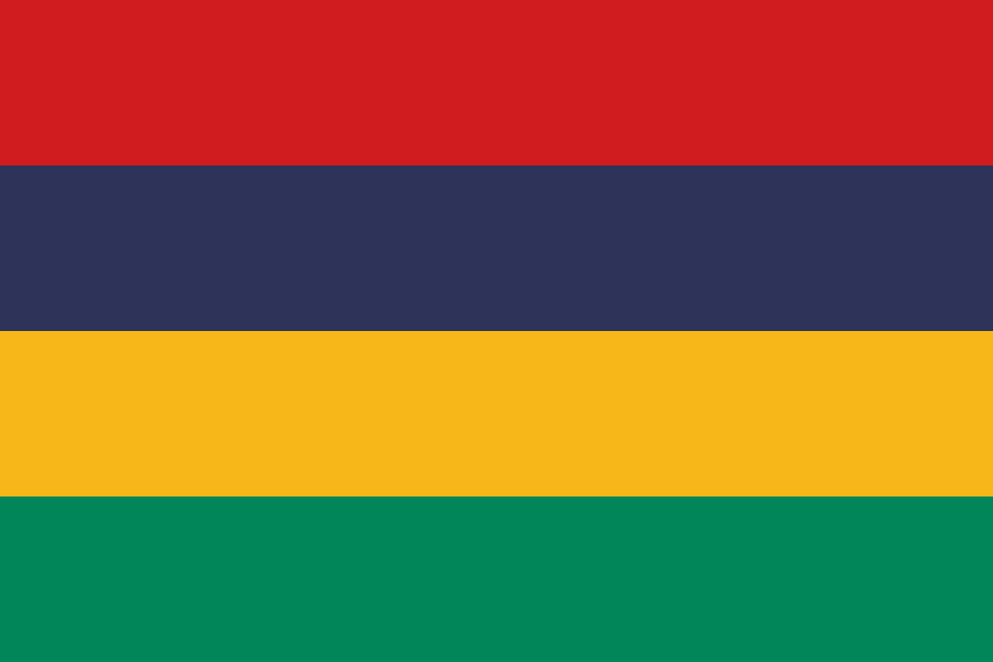

Mauritius in the World

Mauritius - Introduction 2011
top of pageBackground: Although known to Arab and Malay sailors as early as the 10th century Mauritius was first explored by the Portuguese in the 16th century and subsequently settled by the Dutch - who named it in honor of Prince Maurits van NASSAU - in the 17th century. The French assumed control in 1715 developing the island into an important naval base overseeing Indian Ocean trade and establishing a plantation economy of sugar cane. The British captured the island in 1810 during the Napoleonic Wars. Mauritius remained a strategically important British naval base and later an air station playing an important role during World War II for anti-submarine and convoy operations as well as the collection of signals intelligence. Independence from the UK was attained in 1968. A stable democracy with regular free elections and a positive human rights record the country has attracted considerable foreign investment and has earned one of Africa's highest per capita incomes. Recent poor weather declining sugar prices and declining textile and apparel production have slowed economic growth leading to some protests over standards of living in the Creole community.
Area
Total: 2,040 km²
Rank: 181
Land: 2,030 km²
Water: 10 km²
Note: includes Agalega Islands Cargados Carajos Shoals (Saint Brandon) and Rodrigues
Comparative: almost 11 times the size of Washington DC
Maritime claims: measured from claimed archipelagic straight baselines
Territorial sea: 12 nm
Exclusive economic zone: 200 nm
Continental shelf: 200 nm or to the edge of the continental margin
Climate: tropical modified by southeast trade winds; warm dry winter (May to November); hot wet humid summer (November to May)
Natural hazards: cyclones (November to April); almost completely surrounded by reefs that may pose maritime hazards
Geography
Note: the main island from which the country derives its name is of volcanic origin and is almost entirely surrounded by coral reefs; home of the dodo a large flightless bird related to pigeons driven to extinction by the end of the 17th century through a combination of hunting and the introduction of predatory species
Mauritius - People 2011
top of pagePopulation: 1,303,717 (July 2011 est.)
Rank: 154
Growth rate: 0.729% (2011 est.)
Growth rate rank: 138
Below poverty line: 8% (2006 est.)
Languages: Creole 80.5% Bhojpuri 12.1% French 3.4% English (official; spoken by less than 1% of the population) other 3.7% unspecified 0.3% (2000 census)
Religions: Hindu 48% Roman Catholic 23.6% Muslim 16.6% other Christian 8.6% other 2.5% unspecified 0.3% none 0.4% (2000 census)
Age structure
0-14 years: 21.8%
15-64 years: 70.7% (male 457,743/female 463,875)
65 years and over: 7.5% (male 38,944/female 58,391) (2011 est.)
Urbanization
Urban population: 42% of total population
Rate of urbanization: 0.8% annual rate of change (2010-15 est.)
Environment
Current issues: water pollution degradation of coral reefs
International agreements party to: Antarctic-Marine Living Resources Biodiversity Climate Change Climate Change-Kyoto Protocol Desertification Endangered Species Environmental Modification Hazardous Wastes Law of the Sea Marine Life Conservation Ozone Layer Protection Ship Pollution Wetlands
International agreements signed but not ratified: none of the selected agreements
Sex ratio
At birth: 1.05 male/female
Under 15 years: 1.04 male(s)/female
15-64 years: 0.99 male(s)/female
65 years and over: 0.67 male(s)/female
Total population: 0.97 male(s)/female (2011 est.)
Infant mortality rate
Total: 11.52 deaths/1000 live births
Rank: 139
Male: 13.7 deaths/1000 live births
Female: 9.23 deaths/1000 live births (2011 est.)
Life expectancy at birth
Total population: 74.48 years
Rank: 99
Male: 71.01 years
Female: 78.12 years (2011 est.)
Drinking water source:
urban: 100% of population
rural: 99% of population
total: 99% of population
urban: 0% of population
rural: 1% of population
total: 1% of population (2008)
rural: 99% of population
total: 99% of population
urban: 0% of population
rural: 1% of population
total: 1% of population (2008)
Sanitation facility access:
urban: 93% of population
rural: 90% of population
total: 91% of population
urban: 7% of population
rural: 10% of population
total: 9% of population (2008)
rural: 90% of population
total: 91% of population
urban: 7% of population
rural: 10% of population
total: 9% of population (2008)
Hivaids
Adult prevalence rate: 1% (2009 est.)
Adult prevalence rate rank: 47
People living with hivaids: 8,800 (2009 est.)
People living with hivaids rank: 102
Deaths: fewer than 500 (2009 est.)
Deaths rank: 93
Literacy
Definition: age 15 and over can read and write
Total population: 84.4%
Male: 88.4%
Female: 80.5% (2000 census)
School life expectancy primary to tertiary education
Total: 14 years
Male: 13 years
Female: 14 years (2008)
Mauritius - Government 2011
top of pageCountry name
Conventional long form: Republic of Mauritius
Conventional short form: Mauritius
Local long form: Republic of Mauritius
Local short form: Mauritius
Capital
Name: Port Louis
Geographic coordinates: 20 09 S 57 29 E
Time difference: UTC+4 (9 hours ahead of Washington DC during Standard Time)
Administrative divisions: 9 districts and 3 dependencies*; Agalega Islands* Black River Cargados Carajos Shoals* Flacq Grand Port Moka Pamplemousses Plaines Wilhems Port Louis Riviere du Rempart Rodrigues* Savanne
International law organization participation: accepts compulsory ICJ jurisdiction with reservations; accepts ICCt jurisdiction
Executive branch
Chief of state: President Sir Anerood JUGNAUTH ; Vice President Monique OHSAN-BELLEPEAU (since 13 November 2010)
Head of government: Prime Minister Navinchandra RAMGOOLAM (since 5 July 2005)
Cabinet: Council of Ministers appointed by the president on the recommendation of the prime minister
Elections: president and vice president elected by the National Assembly for five-year terms (eligible for a second term); elections last held on 19 September 2008 (next to be held in 2013); prime minister and deputy prime minister appointed by the president responsible to the National Assembly
Election results: Sir Anerood JUGNAUTH reelected president by unanimous vote; percent of vote by the National Assembly - NA
Legislative branch: unicameral National Assembly (70 seats; 62 members elected by popular vote 8 appointed by the election commission to give representation to various ethnic minorities; members to serve five-year terms)
Elections: last held on 5 May 2010 (next to be held in 2015)
Election results: percent of vote by party - NA; seats by party - AF 41 MMM 18 MR 2 MSF 1; appointed seats - to be assigned 8
Political parties and leaders: Alliance of the Future or AF [Navinchandra RAMGOOLAM] (governing coalition - includes MLP MMSM MR MSD PMSD); Mauritian Labor Party or MLP [Navinchandra RAMGOOLAM]; Mauritian Militant Movement or MMM [Paul BERENGER]; Mauritian Militant Socialist Movement or MMSM [Pravind JUGNAUTH]; Mauritian Socialist Militant Movement or MSMM [Madan DULLOO]; Mauritian Solidarity Front of FSM [Cehl FAKEERMEEAH]; Mouvement Republicain or MR [Jayarama VALAYDEN]; Maurition Social Democratic Party or PMSD [Xavier Luc DUVAL]; Rodrigues Movement or MR [Joseph (Nicholas) Von MALLY]; Rodrigues Peoples Organization or OPR [Serge CLAIR]
International organization participation: ACP AfDB AOSIS AU C COMESA CPLP (associate) FAO G-77 IAEA IBRD ICAO ICRM IDA IFAD IFC IFRCS IHO ILO IMF IMO IMSO InOC Interpol IOC IOM IPU ISO ITSO ITU ITUC MIGA NAM OIF OPCW PCA SAARC (observer) SADC UN UNCTAD UNESCO UNIDO UNWTO UPU WCO WFTU WHO WIPO WMO WTO
Diplomatic representation
In the us chief of mission: Ambassador Somduth SOBORUN
In the us chancery: 1709 N Street NW Washington DC 20,036; administrative offices - 3,201 Connecticut Avenue NW Suite 441 Washington DC 20,036
In the us telephone: [1] (202) 244-1491 through 1492
In the us fax: [1] (202) 966-0983
From the us chief of mission: Ambassador ; Charge d'Affaires Troy FITRELL
From the us embassy: 4th Floor Rogers House John Kennedy Street Port Louis
From the us mailing address: international mail: P. O. Box 544 Port Louis; US mail: American Embassy Port Louis US Department of State Washington DC 20,521-2,450
From the us telephone: [230] 202-4,400
From the us fax: [230] 208-9,534
Flag description: four equal horizontal bands of red (top) blue yellow and green; red represents self-determination and independence blue the Indian Ocean surrounding the island yellow has been interpreted as the new light of independence golden sunshine or the bright future and green can symbolize either agriculture or the lush vegetation of the island
National anthem
Name: 'Motherland'
Lyricsmusic: Jean Georges PROSPER/Philippe GENTIL
Note: adopted 1968
Mauritius - Economy 2011
top of pageEconomy overview: Since independence in 1968 Mauritius has developed from a low-income agriculturally based economy to a middle-income diversified economy with growing industrial financial and tourist sectors. For most of the period annual growth has been in the order of 5% to 6%. This remarkable achievement has been reflected in more equitable income distribution increased life expectancy lowered infant mortality and a much-improved infrastructure. The economy rests on sugar tourism textiles and apparel and financial services and is expanding into fish processing information and communications technology and hospitality and property development. Sugarcane is grown on about 90% of the cultivated land area and accounts for 15% of export earnings. The government's development strategy centers on creating vertical and horizontal clusters of development in these sectors. Mauritius has attracted more than 32,000 offshore entities many aimed at commerce in India South Africa and China. Investment in the banking sector alone has reached over $1 billion. Mauritius with its strong textile sector has been well poised to take advantage of the Africa Growth and Opportunity Act (AGOA). Mauritius' sound economic policies and prudent banking practices helped to mitigate negative effects from the global financial crisis in 2008-09. GDP grew 3.6% in 2010 and the country continues to expand its trade and investment outreach around the globe.
Real gdp purchasing power parity:
$17.36 billion (2009 est.)
$16.85 billion (2008 est.)
$16.85 billion (2008 est.)
Rank: 129
Note: data are in 2010 US dollars
Industries: food processing (largely sugar milling) textiles clothing mining chemicals metal products transport equipment nonelectrical machinery tourism
Labor force: 597,300 (2010 est.)
Rank: 154
By occupation agriculture and fishing: 9%
By occupation construction and industry: 30%
By occupation transportation and communication: 7%
By occupation trade restaurants hotels: 22%
By occupation finance: 6%
By occupation other services: 25% (2007)
Budget
Revenues: $2.028 billion
Expenditures: $2.478 billion (2010 est.)
Surplus or deficit: -4.6% of GDP (2010 est.)
Surplus or deficit rank: 137
Market value of publicly traded shares:
$4.74 billion (31 December 2009)
$3.443 billion (31 December 2008)
$3.443 billion (31 December 2008)
Rank: 81
Exports: $1.942 billion (2009 est.)
Rank: 128
Commodities: clothing and textiles sugar cut flowers molasses fish
Partners: UK 19% France 16.8% US 11% Madagascar 8.4% Italy 7.9% South Africa 6% Spain 4.9% (2010)
Imports: $3.499 billion (2009 est.)
Rank: 127
Commodities: manufactured goods capital equipment foodstuffs petroleum products chemicals
Partners: India 20.3% France 10.6% China 10.3% South Africa 9.7% (2010)
Exchange rates:
Mauritian rupees (MUR) per US dollar -
30.991 (2010)
31.96 (2009)
27.973 (2008)
31.798 (2007)
31.656 (2006)
30.991 (2010)
31.96 (2009)
27.973 (2008)
31.798 (2007)
31.656 (2006)
Mauritius - Energy 2011
top of pageElectricity
Production: 2.402 billion kWh (2008 est.)
Production rank: 130
Consumption: 2.234 billion kWh (2008 est.)
Consumption rank: 134
Exports: 0 kWh (2009 est.)
Imports: 0 kWh (2009 est.)
Natural gas
Production: 0 m³ (2009 est.)
Production rank: 100
Consumption: 0 m³ (2009 est.)
Consumption rank: 205
Exports: 0 m³ (2009 est.)
Exports rank: 145
Imports: 0 m³ (2009 est.)
Imports rank: 152
Proven reserves: 0 m³ (1 January 2011 est.)
Proven reserves rank: 168
Mauritius - Communication 2011
top of pageTelephones
Main lines in use: 387,700 (2010)
Main lines in use rank: 105
Mobile cellular: 1.191 million (2010)
Mobile cellular rank: 146
Telephone system
General assessment: small system with good service
Domestic: monopoly over fixed-line services terminated in 2005; fixed-line teledensity roughly 30 per 100 persons; mobile-cellular services launched in 1989 with teledensity in 2009 reaching 85 per 100 persons
International: country code - 230; landing point for the SAFE submarine cable that provides links to Asia and South Africa where it connects to the SAT-3/WASC submarine cable that provides further links to parts of East Africa and Europe; satellite earth station - 1 Intelsat (Indian Ocean); new microwave link to Reunion; HF radiotelephone links to several countries (2009)
Broadcast media: the government maintains control over TV broadcasting through the Mauritius Broadcasting Corporation (MBC) which operates 3 analog and 10 digital TV stations; MBC is a shareholder in a local company that operates 2 pay TV stations; the state retains the largest radio broadcast network with multiple stations; several private radio broadcasters have entered the market since 2001; transmissions of at least 2 international broadcasters are available (2007)
Mauritius - Military 2011
top of pageMauritius - Transportation 2011
top of pageAirports: 5 (2010)
Rank: 182
With paved runways total: 2
With paved runways over 3047 m: 1
With paved runways 914 to 1523 m: 1 (2010)
With unpaved runways total: 3
With unpaved runways 914 to 1523 m: 2
With unpaved runways under 914 m: 1 (2010)
Mauritius - Transnational issues 2011
top of pageDisputes international: Mauritius and Seychelles claim the Chagos Islands; claims French-administered Tromelin Island
Illicit drugs: consumer and transshipment point for heroin from South Asia; small amounts of cannabis produced and consumed locally; significant offshore financial industry creates potential for money laundering but corruption levels are relatively low and the government appears generally to be

🅶🅷🅴🅾🆂.🅲🅾🅼